'Inadequate infrastructure' for thousands of new homes around Warwick
By James Smith 12th Apr 2026
")

There is "inadequate infrastructure" for thousands of extra houses to be built near Warwick, residents have said.
Warwick and Stratford-on-Avon District Councils have published the results of a major public consultation into the new South Warwickshire Local Plan (SWLP) which will decide where tens of thousands of houses are built locally over the next 25 years.
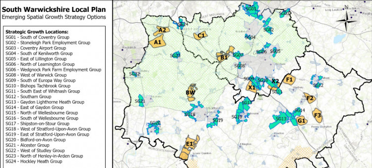
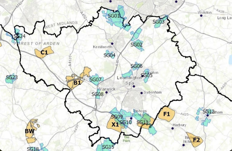
As well as 12 potential locations for 'new settlements' - which Hatton is included in - the councils have also outlined several areas for "strategic growth" around local towns.
Two of these areas are near Warwick: the 'west of Warwick group' and 'Wedgnock Park Farm employment group'.
West of Warwick
Locals were split over the development of the 'west of Warwick area' - referred to as SG08 in the documents.
The land borders the A46, with some describing it as an "infill development".
Nearly 140 locals shared their views on the land, with 69 supporting the idea of it being developed, and 68 opposing it.

"SG08 is viewed by some respondents as infill development, which could weaken rural character, increase car dependency and disrupt settlement patterns without new walking and cycle links," the council report said.
"Though some felt that SG08 may be an appropriate extension of urban Warwick given its adjacency to existing residential development."
Concerns including congestion on local roads, loss of open fields, the impact on the floodplain and the fact local services are already "strained" were raised by locals.
Wedgnock Park Farm
The other area of land earmarked around Warwick is to the west of the A46, between Warwick and Hatton, along the Birmingham Road.
Views on this parcel of land were less split, with 257 of 306 responses objecting to the area being included in SWLP.
"Local roads and junctions around the A46 and Birmingham Road are already congested and unsafe, with narrow lanes unsuitable for heavy goods vehicles and rail and bus services lacking capacity, accessibility or realistic scope for expansion," feedback from locals said.

"SG07 lies entirely within the green belt, risking breach of national policy and loss of farmland, habitats, heritage features and countryside separation.
"The site adjoins ancient woodland and key wildlife corridors, endangering protected species and landscape character, while high-grade agricultural land vital for food security could be irreversibly lost.
"Existing healthcare, schools, utilities and drainage systems are at capacity, with flood risk raised due to inadequate infrastructure.
"Brownfield and non-green belt sites are cited as preferable alternatives."
South Warwickshire's future
The results of the survey were published last month as part of a 595-page report feeding back the results of the public survey.
An abridged 76-page summary report has also been shared.
Both highlighted there were public concerns about the "lack of infrastructure to support the proposed quantum of growth" across the whole of South Warwickshire.

"It was considered that the proposed amount of growth will have a detrimental impact on the plan area," the report said.
It added: "Commentary from respondents revealed a significant divide between the councils' aspirations and the public's perception of the plan's feasibility, with a wide range of responses received."
The much-delayed document is yet to be finalised, but will ultimately govern where some 35,000 houses are built in the region.
CHECK OUT OUR Jobs Section HERE!
warwick vacancies updated hourly!
Click here to see more: warwick jobs


Share:
")
")